Synopsis: A disturbance with the potential of becoming Tropical Cyclone Two currently in the Atlantic Ocean. At 11:00 hrs (1500 UTC), the disturbance was centred near latitude 8.8 North 56.8 West (approximately 290 Km to the North Northeast of Georgetown) (Figure 1) and is moving towards the West with a speed of 11 meters per second. As the system moves further to the West, it is expected to come closer to Guyana’s Coast. The estimated minimum central pressure is 1005 mb (29.68 inches of Mercury) with maximum sustained winds of 18 meters per second.
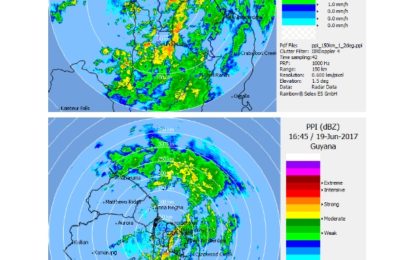
Current weather conditions over Guyana: Cloudy to overcast skies are being observed throughout Guyana. Regions 5, 6, 8 and 10 are currently experiencing moderate showers with frequent rain and thundershowers (See Radar Images below). During the next 1 to 4 hours Regions 1 to 4 and 7 should begin to observe similar conditions. Thundershowers are likely to generate gusty winds. Rainfall is likely to accumulate between 30 mm and 60 mm during the next 6 hours.
Regions 1 to 3 and 7 are expected to experience the highest rainfall totals. The system is expected to generate wind waves between 2.0 m and 3.5 m in open waters, with the highest waves north of the centre.
Possible impacts of the forecast Weather:
WATER ACCUMULATION/FLOODING IS LIKELY TO OCCUR THROUGHOUT THE COASTAL REGIONS. THERE IS AN INCREASED RISK OF HILLY LOCATIONS EXPERIENCING LANDSLIDES/MOVEMENTS.


