 Tue, Jun 30, 2026


 Tue, Jun 30, 2026


Oil production, other offshore activities now monitored in ‘real time’ by EPA


The Environmental Protection Agency’s (EPA) capacity to effectively monitor activities offshore Guyana, such as the ongoing oil production, has been significantly boosted with the start-up of its real-time monitoring system.
Though, only in its testing phase, the new real-time monitoring technology, from the EPA can track and monitor all offshore activities.
This technology serves as an integral component in managing Guyana’s nascent oil and gas sector, ensuring that operators are in compliance with the necessary safety protocols. And with this system, the EPA no longer has to depend on the information that is trickled down from the operators.
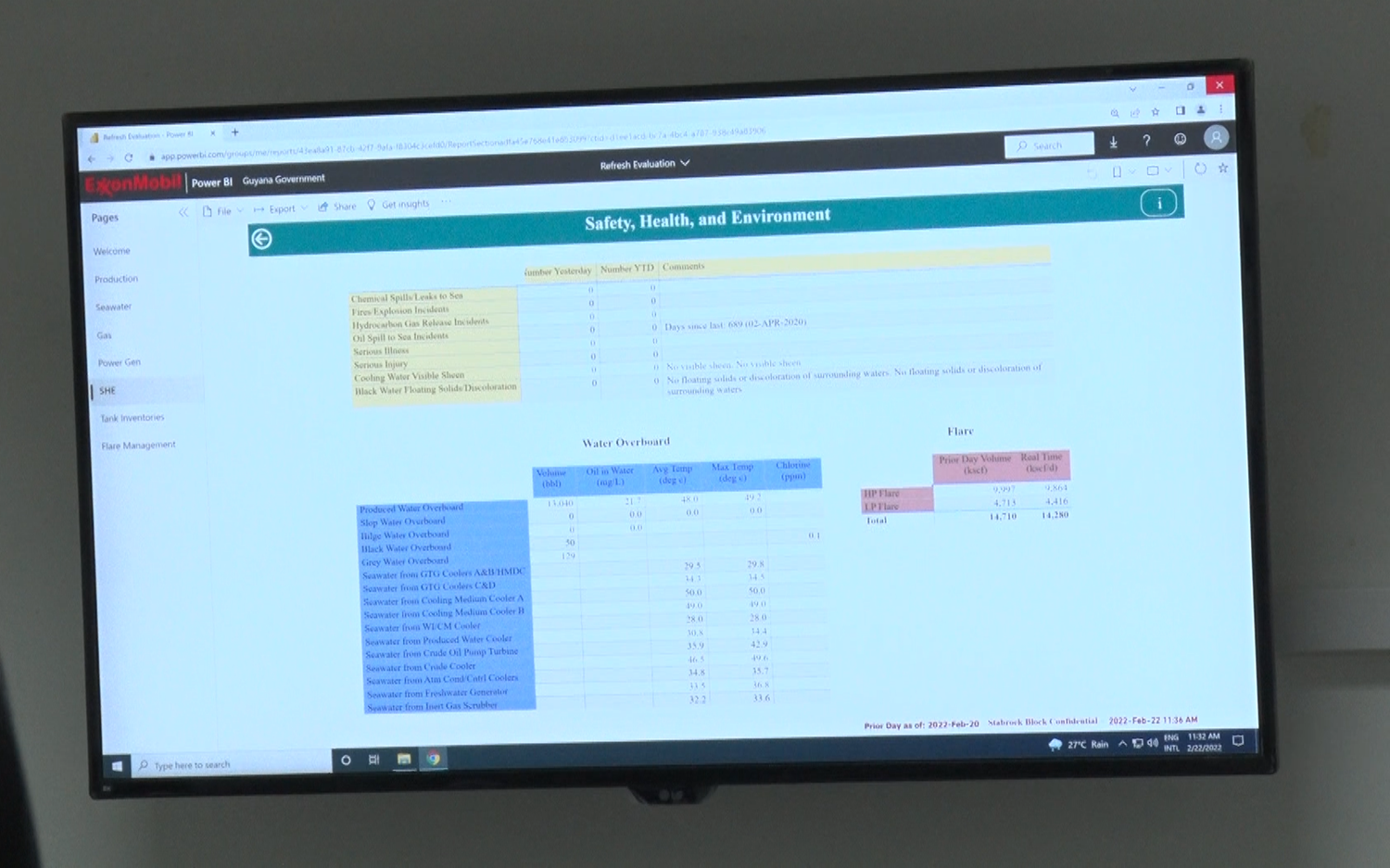
On Tuesday, at the EPA’s Head Office in Georgetown, Head of the Agency’s Oil and Gas Unit Joel Gravesande gave the media a simple play-by-play of how exactly the system works in the “Situation Room” to capture information on the Liza Destiny oil ship docked in the Stabroek Block.
With sensors tagged on the ship, the EPA will have access to production numbers, gas levels and power generation
“We can also monitor chemical spills, if they were in chemical spills, fires, hydrocarbon gas releases, oil spills, illnesses, injuries, cooling water, if there’s any visible sheen when the cooling water is discharged, and blackwater, if there is any solid or discolouration with it,” he explained.
The real-time monitoring system also allows the EPA to monitor the flare valves aboard the Liza Destiny, Gravesande explained.
“You could see the flash gas flash gas compressor, and the main gas compressor and of course, the gas that is being flared right now, in real-time,” he added.
In addition to that, the agency can monitor flaring levels using a satellite that can track thermal heat signatures.
And according to Reshana Thomas, the EPA’s Geographic Information System (GIS) Specialist, the agency can determine whether flaring activities exceed the mandated levels outlined in the Environmental Permits.
If the levels reach a peak, Thomas noted that an email alert is sent to the Director and other officers within the Situation Room.
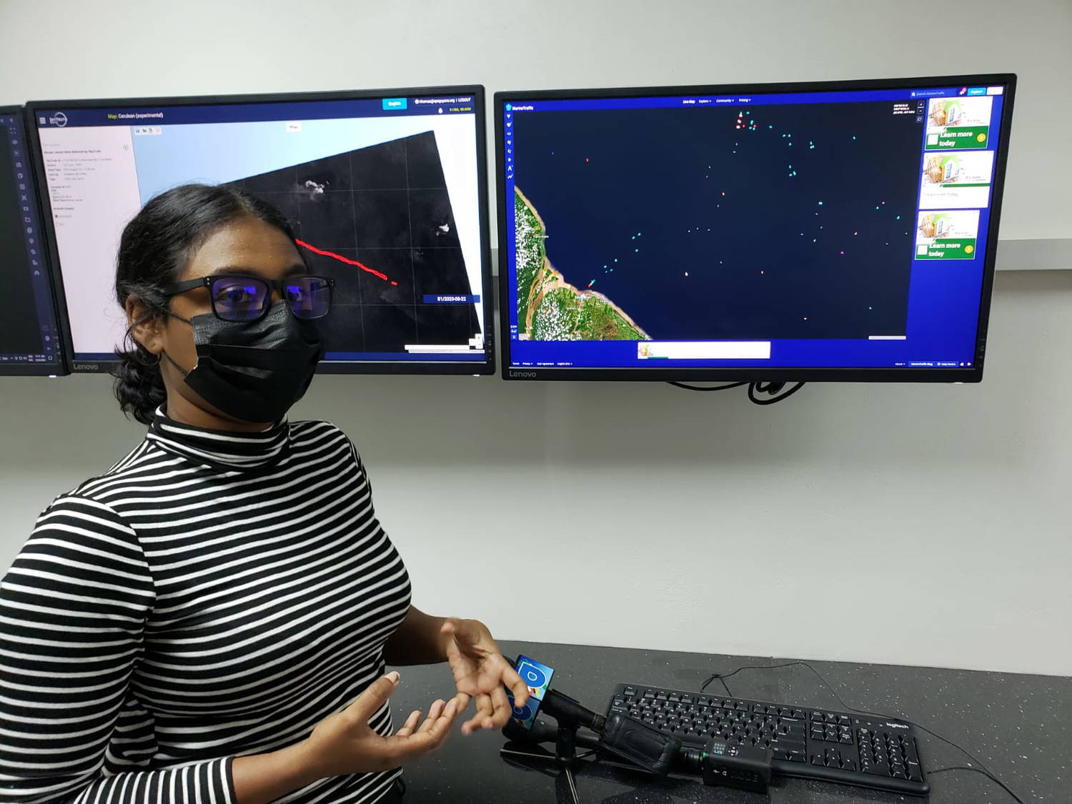
“This tells us where it has happened, the brightness temperature of the channel, and the radiative power…if it is above a certain number, that oil and gas department determines, then it is categorized as a flaring activity and we take this data and internally do our calculations to determine what the emissions are,” she added.
It was noted that operators in the Stabroek Block are still mandated to submit their monthly and weekly reports on activities offshore. That information is then compared to what the EPA has logged from their own system.
And even though the EPA now has real-time monitoring capacity, the Executive Director, Khemraj Parsram noted too that the EPA will still be conducting on-site visits.
He explained that with the close to one billion sum allocated to the EPA in the 2022 National Budget, the agency plans to extend the monitoring capabilities further.
“The government sees the value in strengthening the capacity of the Agency to ensure that we can monitor the oil and gas sector effectively…issuing a permit is one thing, but the key thing is compliance monitoring and that is our focus,” he said.